Live Weather from WRUF-TV
Current Conditions
Weather Forecast from FPREN
Latest Weather News
-
 Strong spring storm system to elevate risk for strong storms across Florida Tuesday night and Wednesday
 -
 Severe storms with flooding risk across north Florida through Wednesday


-
 Freeze alerts are already in effect for the Panhandle and North Florida as temperatures are expected to drop to the lowest they've been in over a year.
 -
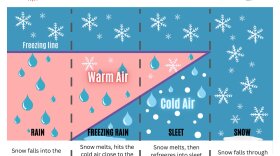 Residents of the Panhandle woke up to an uncommon sight on Tuesday morning: Snow flurries and freezing rain. The conditions were brought on by the passage of a strong cold front through the Mississippi Valley and the Southeast.
 -
 Sub freezing lows are forecasted for the Panhandle and North Florida on Wednesday morning. Wind chills in the 30s are expected as far south as Tampa and Orlando.
 -
 Just days after strong storms and numerous tornadoes across the Panhandle, the risk for severe thunderstorms returns
 -
 A severe weather system tracked across the Southeast this morning, and it spawned reports of tornadoes and damaging wind gusts across Florida’s Panhandle.
 -
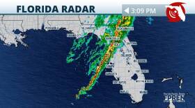
 The same system that produced damaging winds and tornado reports is entering the Florida peninsula this afternoon. Impacts to continue into the evening.
 -
 Parts of north central Florida and southern Georgia face the potential for severe weather on Tuesday.
 -
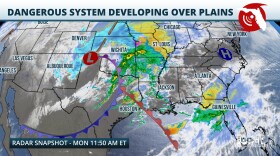 Multiple rounds of dangerous thunderstorms are expected as another strong winter storm barrels across the country. Damaging winds and a few tornadoes (potentially strong) are possible, especially over the Panhandle and North Florida.
 -
 While Florida is known for its generally mild winters compared to many other parts of the country, winter weather, including sub-freezing temperatures, freezing rain, and even snow, are possible over parts of the state.
 -
 Floridians may not be wearing mittens and scarfs this Christmas. A frontal system moving through will increase chances for showers and thunderstorms on Sunday and Monday for much of the state.


